01
Connect the evidence
Bring monitoring data, spatial context, and model output into one traceable scientific view.
Loading…
Pipelining text and images


Project RAIN is funded by the U.S. Department of Energy through the Genesis Mission to accelerate AI-enabled scientific discovery.
AI for water science
RAIN advances science-informed AI for complex water systems—connecting observations, physical models, and uncertainty into research workflows people can inspect and trust.
The project
Water research rarely fits inside one dataset or one model. RAIN is built around the relationships between them: observations and simulations, local measurements and system-scale behavior, fast AI inference and physical understanding.
A U.S. Department of Energy-led national initiative
The Genesis Mission is led by the U.S. Department of Energy and its 17 National Laboratories. Project RAIN is funded by DOE through the Genesis Mission, joining a national effort to connect scientific data, advanced computing, experimental facilities, and AI.
01
Bring monitoring data, spatial context, and model output into one traceable scientific view.
02
Use information theory and unsupervised ML to tease apart nonlinear, complex interdependencies while respecting the full descriptive power of the data.
03
Use physical constraints to guide learning, expose implausible results, and focus computation where it matters.
04
Turn uncertainty from a footnote into an explicit part of research questions, comparisons, and decisions.
Project partners
RAIN is being developed with national-laboratory and university collaborators whose expertise spans water science, subsurface-system modeling, scientific computing, and artificial intelligence.
Scientific foundation
RAIN builds on an established technical lineage of interpretable AI for water science. In a 2022 study co-authored by EnviTrace CTO Velimir Vesselinov, researchers combined climate projections, a process-based hydrologic model, and NMFk to reveal spatial and seasonal drought patterns across 134 Colorado River Basin subwatersheds.
The study showed how AI can extract interpretable spatial and temporal patterns that researchers can relate to physical processes, while keeping differences between climate scenarios visible. RAIN carries those principles forward—from regional surface-water analysis to integrated research on coupled surface-water and subsurface systems, using observations, physical models, advanced computing, and explicit uncertainty.
Related peer-reviewed work
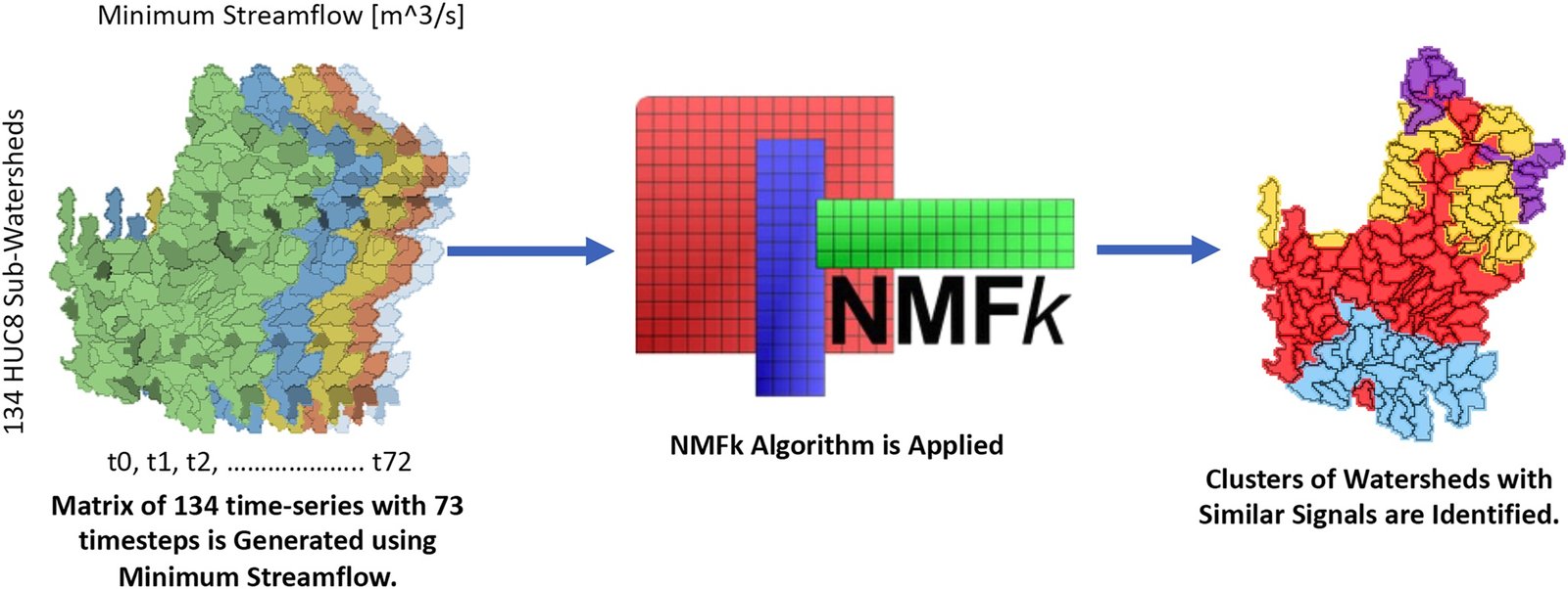
Figure 2 · From data to patterns
NMFk organizes 134 subwatershed time series into a matrix, extracts shared signals, and maps watersheds with similar behavior—the paper's clearest example of moving from raw model output to interpretable structure.
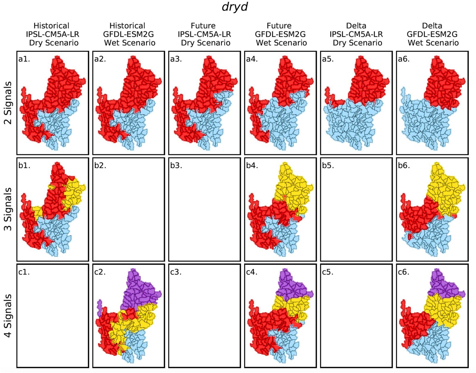
Figure 6 · Where patterns change
Spatial clusters compare historical and future dry-day behavior, plus the delta between them, under dry and wet scenarios. Blank panels indicate that NMFk found no acceptable solution; colors identify separate clusters within each panel and should not be compared across panels.
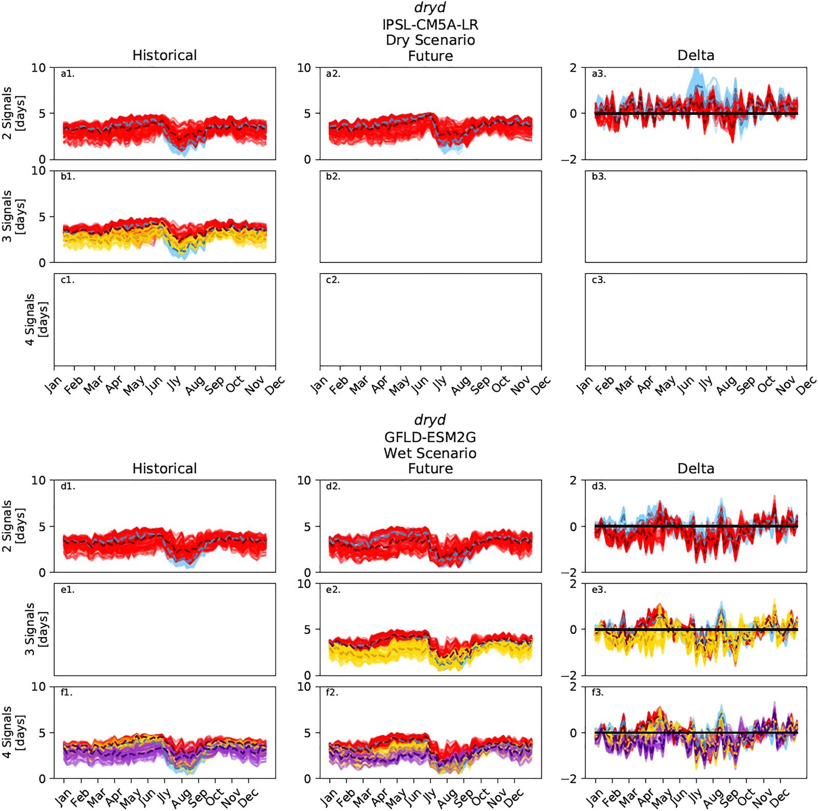
Figure 7 · When patterns change
Seasonal dry-day signals correspond to the spatial clusters in Figure 6. Individual lines represent subwatersheds and dashed lines mark cluster medians, making the timing and scenario dependence of those patterns visible.
Figures reproduced without modification from Talsma, Bennett & Vesselinov (2022), Earth and Space Science, doi:10.1029/2021EA002086. © 2022 The Authors, licensed under CC BY 4.0. Captions condensed for the web.
Research workflow
RAIN frames AI as a scientific collaborator: one that can organize evidence, learn across scales, and keep the physical story visible.
Observe, collect and align measurements across space, time, and source.
Create analysis-ready descriptions of the system and its context.
Combine AI, simulation, and domain constraints to test explanations.
Use new evidence and uncertainty to guide the next research cycle.
Explore EnviCloud
Try interactive public demos that bring these ideas to life.
See how patterns and useful detail emerge in one- and two-dimensional data.
Open demo (opens in a new tab)Explore cost, carbon, and freshwater tradeoffs in a connected resource system.
Open demo (opens in a new tab)Calibrate a model and identify influential, uncertain, or poorly constrained inputs.
Open demo (opens in a new tab)Built for discovery
Connect with EnviTrace to discuss the RAIN project, scientific collaboration, or related AI and water-system research.
Start a conversation