
Mapping Geothermal Temperature: Where Physics Meets Machine Learning
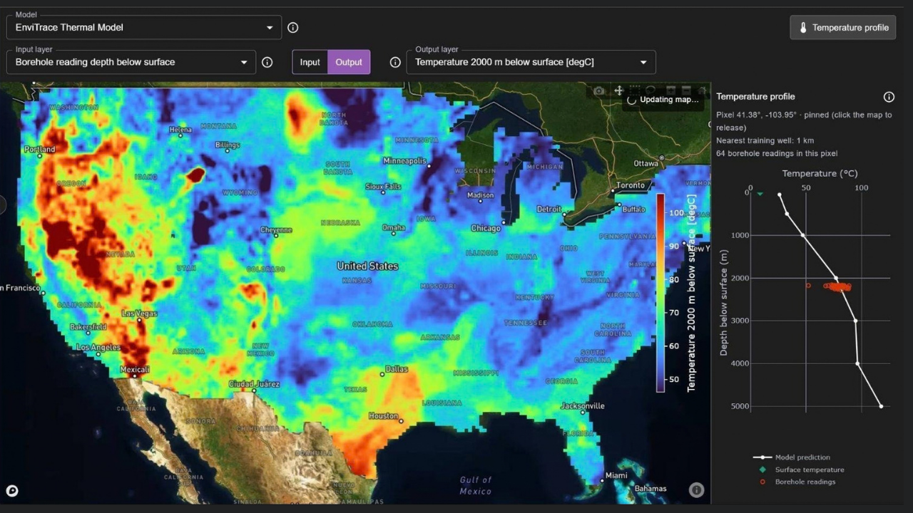
EnviTrace’s machine-learning prediction of geothermal temperature at a depth of 2000m below the ground surface. The temperature profile (panel on the right) shows the ML-predicted geothermal temperature as a function of depth, with the location marked by a yellow star on the map; red dots show temperature measurements from nearby wells that serve as the model's training targets.
For more geothermal predictions, information, analyses, and/or tools, visit our Physics-Informed Geospatial AI dashboard at Cloud.EnviTrace.com.
Understanding how temperature varies in the Earth’s crust is fundamental to geothermal exploration. Yet, predicting vertical temperature profiles far from wells remains difficult: there are few direct measurements, and these are unevenly distributed. To complicate matters further, the processes controlling geothermal conditions vary across both geologic reservoirs and depth; they are complex and never fully characterized.
Past studies have extensively used machine learning (ML) to predict subsurface temperature directly from geologic, geophysical, and geochemical observations. However, these studies have not always been successful in capturing all the observed data. Here, EnviTrace explores an alternative approach by asking a simple question:
What if machine learning does not have to learn the entire temperature field?
Start with what we already know
Rather than predicting subsurface temperature directly from available data, our approach begins with a three-dimensional geothermal model.
At every location, the baseline model estimates how temperature should change with depth using basic physical information, such as depth to basement, surface temperature, and ground surface elevation, along with an initial representation of the regional geothermal gradient.
This baseline result is a simple thermal field representation that is not intended to capture high-resolution geothermal anomalies. It provides a physically meaningful starting point: an estimate of the broad temperature structure we would expect before looking at the detailed observations.
Let machine learning learn what is missing
We then compare this baseline with measured subsurface temperatures.
The difference between the two is the temperature residual. This becomes the machine-learning objective.
Instead of asking the model to predict temperature from scratch, we ask it to learn where and how the observed subsurface departs from the baseline geothermal gradient. Geological, geophysical, geochemical, and other spatial datasets are applied to help explain those discrepancies.
Conceptually, the ML model becomes:
Baseline geothermal field + ML 3D temperature anomaly = Predicted geothermal temperature
This approach produces some fascinating spatial patterns. Features that can be difficult to see in temperature measurements alone become much clearer when expressed as departures from an expected thermal background. The ML results are visualized in the figure above; more information and analyses are available at our Physics-Informed Geospatial AI dashboard at Cloud.EnviTrace.com.
A different way to combine physics and data
Other approaches are tackling the same continent-scale temperature-mapping problem in different ways. The Stanford Thermal Earth Model (developed by Aljubran & Horne in 2024, “Thermal Earth model for the conterminous United States using an interpolative physics-informed graph neural network”), for example, uses a physics-informed graph neural network to jointly estimate subsurface temperature, surface heat flow, and thermal conductivity while incorporating a broad suite of geological and geophysical observations.
Our ML work asks a complementary question: how much of the problem can we explain with a simple physical baseline, and can machine learning concentrate on learning the remaining structure?
Separating those two pieces also gives us a useful way to interrogate the model. We can examine the baseline, the learned correction, and the final temperature prediction independently. This way we can explore which datasets are influencing the correction the most.
Explore the model
The new EnviTrace Thermal Model (available on Cloud.EnviTrace.com) lets users explore these predictions across the conterminous United States and through depth, compare alternative thermal models, and investigate how the predicted subsurface changes as different information is incorporated.
This is ongoing R&D rather than a finished geothermal resource map. But the early results point toward an interesting direction: combining simple, interpretable physical models with machine learning that is focused specifically on where reality departs from that baseline.